
Size Guide
Understanding Mylulusstore Sizing


Description
xTysk kartserie med flotte kart på slitesterkt plastpapir.
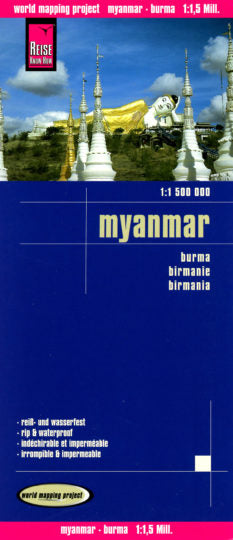
Myanmar / Burma at 1:1,500,000 on an indexed, waterproof and tear-resistant road map with topographic and tourist information, published by Reise Know-How as part of their highly acclaimed World Mapping Project. The map is double-sided to provide the best balance between a good scale and a convenient size sheet, with a very generous overlap between the two sides. Coverage on the southern side extends east to Bangkok and south to Ko Samui and Surat Thani, indicating border crossings to Thailand.
Road and rail networks are easy to see on a clear base which presents topography by light altitude colouring with contours, spot heights, mountain passes and names of mountain ranges. Road network includes selected local tracks and gives driving distances on main roads. Internal administrative boundaries are shown with names of the provinces. National parks and protected areas are marked and symbols highlight various places of interest, including UNESCO world heritage sites, archaeological remains, temples and museums, viewpoints, beaches, etc. The map also shows old versions of many town names (Sittwe / Akyab, Bago / Pegu, Pyay / Prome, etc. Latitude and longitude lines are at intervals of 1º. Extensive index of localities also includes names of national parks, places of interest, etc. Map legend includes English.
Publisert år: 2017
Innbinding: falset
Material: plastpapir
Målestokk: 1:1500000
- Choosing a selection results in a full page refresh.